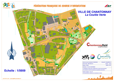


Coulée verte
| Numéro : 2024-D85-52 | Carte : 1 |
| Spécialité : CO à pied | Niveau : Initiation, Scolaire |
| Échelle : 1/5000 | Surface : 1,07 km² |
| Cartographes : Nicolas TALON | |
| Commune la plus proche : CHANTONNAY | |
| Propriétaire : Ville de Chantonnay | |
| Comment et où obtenir la carte. Responsable à contacter :
- Ville de Chantonnay |
|